

Description
For aviators who operate in and around the Kansas City area, the FAA's Kansas City Sectional Aeronautical chart is an affordable, must-have resource for all the relevant, safety-enhancing aeronautical data they need to maintain situational awareness from takeoff to touchdown. As is characteristic of the FAA's entire lineup of sectional charts, the Kansas City Sectional contains such need-to-know aeronautical data as airport info (runway lengths, lighting, elevation, services available, surface type, etc.); airspace dimensions; VHF and LF/MF navigational facilities (frequency, ID, and channel); landmarks; cities & towns; elevation/topographic info; ATC entities and associated contact/radio frequencies; bodies of water; obstructions; and much, much more.
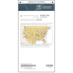
The Kansas City Sectional covers most of Missouri, Eastern Kansas, Northeastern Oklahoma, and slivers of AR, IL, and NE. Uses the standard 1:500,000 (6.86 nm per inch; 2.70 nm per cm) scale characteristic of sectional charts. Updated every six months. A low-cost, value-packed resource that should be a part of every Heartland area pilot's aeronautical arsenal.
The Kansas City Sectional covers most of Missouri, Eastern Kansas, Northeastern Oklahoma, and slivers of AR, IL, and NE. Uses the standard 1:500,000 (6.86 nm per inch; 2.70 nm per cm) scale characteristic of sectional charts. Updated every six months. A low-cost, value-packed resource that should be a part of every Heartland area pilot's aeronautical arsenal.
CHART